The snow from these totals basically fell mid morning to early afternoon on the 18th.
Above: kids on ice on small lake in the Keweenaw 12.16.23
This week looks to be in the mid 40s perhaps we will see some upper 40s. There appears to be rain moving in around Christmas and the storm moving in that may have some snow associated with it appears it will stay well south of the Upper Peninsula in the lower portions of WI, much of IL, and southern portions of the Lower Peninsula of Michigan. If it does in fact lift further north we will most likely see rain, possibly a few brief snow flurries. After this warm period things do look like they will cool down slightly but stay above average through early January.
I’ll go out on a limb here now, I am not confident there will be a single snow station in the UP to record 95-100 inches by January 31st across the UP.
Here is some is some data for you to compare.
Last year by 12.19.22 - average snowfall between 68 snow stations in the UP was 35.5 inches of snow. The lowest season total by the 19th was in Rapid River with 4.1 inches, and highest season total was Ironwood #2 station with 84.8 inches.
Ok so lets compare this year to last year.
This year by 12.19.23 - average snowfall between 68 snow stations in the UP is 13.6 inches of snow. The lowest season total so far is 1 inch at Arnold and the highest season total so far is out of Soo airport with 39.1 inches of snow.
So you can see the difference is 21.9 inches below last season. I compared the same 69 snow stations to each other. Some stations dropped off this year that were measuring last year and there are some new stations this year that aren’t in the data.
Last year between Dec 22nd and Dec 24th we saw 10 snow stations join the 100 Inch Club.
Let’s hope we see a few snowstorms early January.
Paying subscribers make it possible for me to do these snow reports, videos, and live drives. Please consider becoming a paid subscriber so I can drive more often away from the Keweenaw and do more snow reports. Thanks so much for your support.
Also if you aren’t already I would ask you please subscribe to the FunintheUP Youtube channel
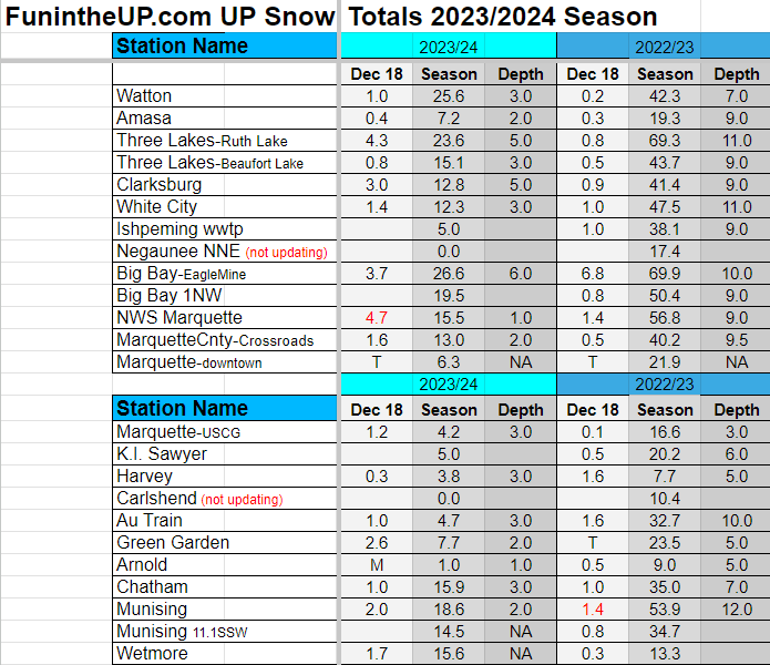
UP Snow Totals Below for Dec 18th.
T = trace, NR = No report, NA = Not Applicable
If daily slot is 0" the station hasn't updated or recorded no snowfall.
Sometimes a station won't update that day and does the next day or even days later.
Tahquamenon Falls State Park only updates at the end of each month.
Keweenaw county only updates during the weekdays.
Sanderson Field Airport (Soo) updates next day.
Most Snowfall Dec 18th: NWS Marquette with 4.7 inches
Most Snowfall, season to date: Soo airport with 39.1 inches
Biggest 24hr snowfall this season: Bergland with 12.3 inches (10.29.23)


