NOTE: may need to open this in the Substack app or view on funintheup.substack.com as this email is longer than email clients support.
Thanks for checking out the Yooper Report, welcome.
UpperPeninsulaTours.com - Guided Adventures across the U.P. of MI
Hidden waterfalls, rock picking, big scenic views, history. Private adventures.
The last 10 days have been snowy especially in the Keweenaw, Painesdale, Calumet, and Central/Delaware where 46 to 64 inches of snow has fallen.
We now have 6 stations in the 200 Inch Club. Twin Lakes just joined today, joining, Calumet Lake, Calumet/Tamarack, Keweenaw county, Painesdale, and Houghton county weather stations. There are two other stations in the eastern U.P. with less than 2 inches to go before they reach it, and with a dry spell coming they might have to wait until next week or longer to join the club. Next two stations are more than 25 inches away so it will be a little bit before they reach it.
Here are some fun stats for a few weather stations for this winter up to today’s snowfall measurement the 19th.
Calumet/Tamarack weather station
I have only had 14 of 89 days with no measurable snowfall since Nov 23rd when the snow finally stuck on the ground on the ground for good. There was 4.3 inches of snow that fell before that but it all melted.
There were 11 days in December with no snowfall. The bulk of the time period with no snow was Dec 21st to Dec 29th where we saw temps as high as 42 degrees on Dec 28th. There has only been 3 days since Jan 1st with no measurable snowfall up to Feb 19th snowfall measurement. Tomorrow morning might break the streak of 20 days in a row with measurable snowfall.
National Weather Service Marquette
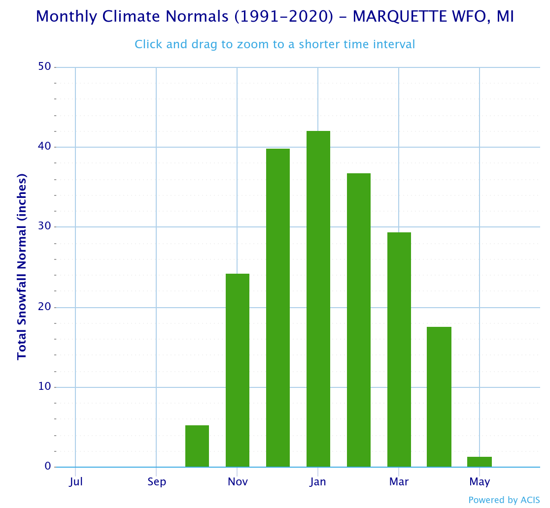
There has been 103.8 inches of snow that has fallen for the season so far. The average snow total for the season is 188 inches with data going back to 61/62. Average snowfall from first snowfall through the month of February is 136.1 inches. There is still another 8 days to get to that average, but 32 inches will be hard to make up. Just to hit the season average the NWS Mqt office needs another 51.9 inches of snow, yes that is possible but without another couple snowstorms before the end of the month, it is unlikely 188 inches of snow will be reached at the NWS office in Negaunee township.
Below I have included some charts for some weather stations in the Upper Peninsula. The monthly and yearly data in the graph only shows the averages from 1991 to 2020, but it gives you an idea of snowfall comparisons to this year so far.
Looking ahead at snow and temperatures
Forecast ahead is a mild one, little snow besides a few flurries in the Keweenaw most likely Sunday into Monday morning. Elsewhere flurries are possible but a low probability at this time.
Temperatures should get above freezing across most of the Upper Peninsula on Sunday, Monday, and Tuesday with a few places possibly seeing it break 40 degrees. Heading into next weekend things should start cooling back down a little closer to normal temps with another possible snowstorm the last few days of the month into the first couple days of March.
If you aren’t already a premium subscriber to the Yooper Report, please consider doing so as it helps to put gas in the tank so I can continue to provide this resource each winter (since 2011/12) and fall for the upcoming 12th Annual Weekly U.P. Fall Color Report. Thanks for your support. —Yooper Steve
FunintheUP Facebook - instagram.com/yoopersteve
instagram.com/funintheup - FunintheUP TikTok
youtube.com/@funintheup - youtube.com/tourdayoop
U.P. Snow Totals for Feb 19th below.
Keep reading with a 7-day free trial
Subscribe to The Yooper Report to keep reading this post and get 7 days of free access to the full post archives.


