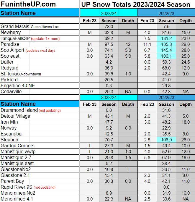
UP Snow Totals Feb 25th/23rd
Snow on the way tonight, then warm weather continues into weekend.
I forgot to upload the snow totals for the 23rd so I listed them below the 25th data, they weren’t much but you can see what stations had snow that day and how much.
The month of February has been a low snowfall month just like December was, about the same amount really, not many stations seeing more than 10 inches for the month so far. However Snow is on the way late tonight into Wednesday afternoon. The cold temps will return for a day along with the high winds with gusts up to 40mph off Pictured Rocks to Whitefish point. Western UP shorelines may see 25-30mph gusts.
In the snow totals today I have highlighted the stations that are in the 100 Inch Club along with what stations were in last year at this time. I have also given a +/- percentage of snowfall compared to last year so you can see how low snow totals really are. Last year we had 35 stations at least 100 inches or more. This year we only have only 4 stations at 100 or more inches.
Above: sunset with Whealkate bluff in foreground, 2.26.24
I got to thinking about historically how we see warmer years with low snowfall years every 10-12 years or so, I can look back on data snow totals from Calumet from 1880s to now and see about 2 years in a row we see some lower than normal snow then it goes back to normal or higher than normal. Now I haven’t really looked hard and it also go me wondering how warmer periods in our weather and low snowfall years correlate with solar maximum, which is now peaking. I will need to do some more research and data analysis on over the years to see what I can find, sounds like a fun project, if I get ambitious enough with all the other stuff I have to do.
Well we are certainly getting down to our last couple months of possible snowfall, months where we usually don’t want to see anymore snow and just wish spring would arrive. Myself I am just ready for spring, but I know that we need more precipitation for the rivers, lakes, and vegetation. Water levels will be down most likely which those who live along the shorelines or have camps are probably ok with after having to deal with lots of erosion a few years prior.
Looking at tonight, we shall see temps drop from the mid 40s down to the single digits in many areas in the UP by early morning. Winds will pick up as the N/NW winds come in from Canada. We will see a bit of drier air sweeping in which will keep snow totals down and it will help keep snow totals from really adding up to more than 3 or 4 inches across most of the UP.
I’ve seen posts saying we are going to be getting 12+ inches, I am not sure where these people are getting those numbers but maybe it’s that hopium really hitting the brain, I just don’t see it with this system, not enough moisture. Drier air will make for some fluffier snow which snow totals could add up but that fluffy snow will settle very very fast into 1 or 2 inches if it was 12 inches. with 16:1 and high as 19:1 ratios expected.
Chances of rain and mixed precipitation is dwindling now as it looks like the warmer air (moisture) will be staying a bit south as ridging is being pushed down a bit by the colder air from the northern Rockies, this isn’t good for those who want those big snow totals. There could be some slick roads late Tuesday night and early Wednesday morning as the ground under the roadways isn’t very frozen anymore so warm roads and some light snow will make for some very slick roads, what looks clear may be black ice.
Everything that I am looking at is projecting higher snow totals to be in the higher region around Herman to Yellow Dog plains and east of Munising to Paradise. It is possible to see 8-10 inches in those places, but more likely 5-7 inches. Western UP and Keweenaw may only see 3-4 inches. Areas from Iron Mountain to Escanaba may see 1-2 inches with areas east of Escanaba seeing 2-4 inches. We shall see though, with those higher SLR ratios we could see some higher snow totals but like I said it won’t add up to much after it settles and melts away with the warmer temperatures returning this weekend. Probably won’t even need to shovel your driveway let the warm temps melt it this weekend.
Snow Totals for Feb 25th and 23rd below.
Left column you can see what percentage lower each station is compared to last year.


