I am making this post today FREE for all, I hope you find it informational, entertaining, and find value. I would love to have you as a monthly or yearly subscriber.
This snowstorm may be one to remember.
Not much snow fell yesterday with a trace of snow, most saw a few tenths of an inch up to a couple inches in areas. Find the snow totals at the bottom. Today we saw some blue skies and some sunshine which was nice to see, especially as we probably won’t see the sun again for over a week with all the lake effect snow continuing to blanket the UP.
If you’ve been wanting snow like I have, it’s on the way, snow, wind, cold, all put into a blender and dropped into the UP all at once. If you’ve lived in the UP for any amount of time during the winter, you know the drill. This should be a fun one to report on, I’ll be out there getting video and photos, and hopefully doing some LIVE videos on Facebook. I have to first find my goggles, mukluks, choppers, windproof winter coat, and wool pants, the wind is going to be crazy, being warm is better than freezing.
So the NWS snow total outlook has changed since the numbers came out this morning, all the numbers have went up a few more inches, a bit more than I think will actually fall, but with lake effect anything is possible, especially if the winds stick around a bit longer on Sunday. It won’t take much wind to keep the lake effect going, Lake Superior being so open is all we need.
Here’s an infographic put together by the NWS Marquette office that gives you an idea of potential snowfall across the UP.
Temps on Sunday and Monday look to be the coldest with single digits and negative single digits in the interior and western UP.
Other than the temps and snow will be the winds impacting the UP. We have a 970smb low that will interact with a low 1040mb high pressure system moving in from Montana area giving a strong pressure gradient. Combine a jet of 850mb that will bring down mixing winds forcing storm force winds over Lake Superior with gusts as high as 45mph in some areas. Yesterday I was saying the NWS may be issuing a blizzard warning, they are talking about it, but we just won't know until it happens, it is very possible. In case you don't know what is considered a blizzard here it is.
A blizzard is:
1. sustained wind of 35mph or more
2. considerable falling and or blowing snow reducing visibility to a 1/4mile or less
3. conditions have to be sustained for 3 consecutive hours at minimum.
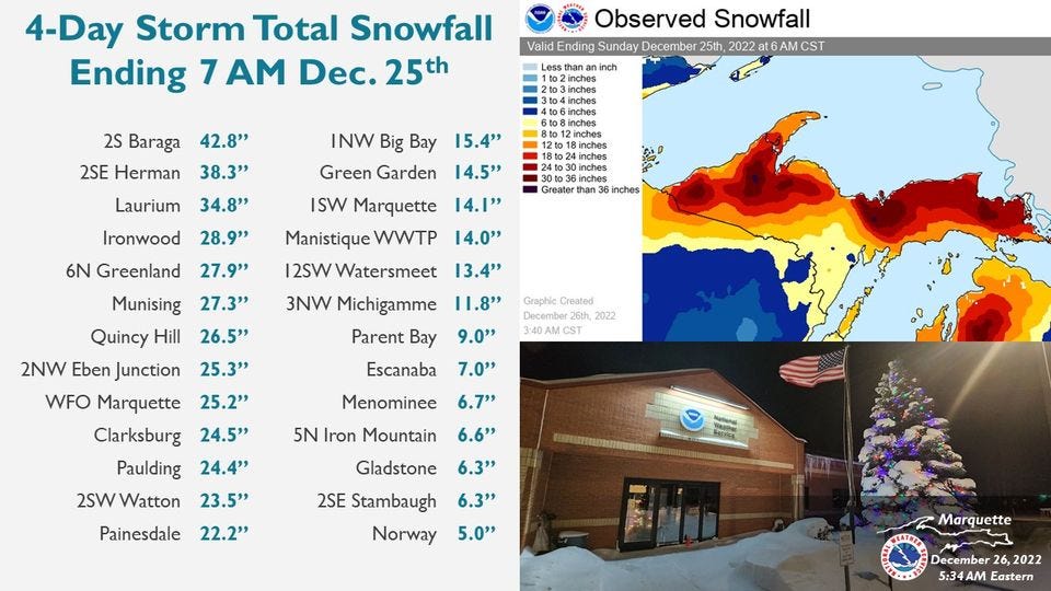
Let’s take a look at snow totals last year during the Christmas storm when we had a blizzard. One of my snow stations hit 34.8 inches for snow that fell 21st-25th. My other stations were: MTU: 23.2”, Dollar Bay: 23”, Calumet lake: 31”, Downtown Houghton: 15.2”, Houghton county: 24.2”.
Will see see these type of snowfall numbers for Friday through Monday? It is possible that is for sure.
Thanks for Subscribing to the Yooper Report UP Snow Report.
Now onto the snow totals for Jan 10th below.
T = trace, NR = No report, NA = Not Applicable
If daily slot is 0" the station hasn't updated or recorded no snowfall.
Sometimes a station won't update that day and does the next day or even days later.
Tahquamenon Falls State Park only updates at the end of each month.
Keweenaw county only updates during the weekdays.
Sanderson Field Airport (Soo) updates next day.
Most Snowfall Jan 10th: Menominee No2 with 2.2 inches
Most Snowfall, season to date: Soo Airport with 48.6 inches
Biggest 24hr snowfall this season: Bergland with 12.3 inches (10.29.23)
The last couple days we’ve had changes in the #1 snow position between Bergland, Soo airport, and Paradise, after this storm we should see a little separation and perhaps even a new station to take over the number one spot.
Remember on Mondays at 5pm you can watch my LIVE at 5 TOP 10 Snowiest Places in the UP video on Facebook.


