The snowstorm dropped a bit of snow across the UP the last few days, and it still has decided to continue across the Keweenaw. Regions of Marquette, Baraga , Houghton, and Keweenaw counties saw places snow stations with totals from 20-32 inches in the last 3 days. Our best storm since December last year for the Christmas storm that dumped upwards of 20-35 inches in places across the Upper Peninsula.
Above: vehicle in ditch by Swedetown 1.15.24
I didn’t get to the Top 10 snow report on Facebook today as I had a lot of snow to shovel, I was backlogged and with there being another 10-15” on the way I can’t get that far behind. Plus it was 0 degrees that makes for a pretty cold time standing there reading off snow totals with wind whipping across your face, maybe that would be entertaining standing there mumbling words with my lips turning purple. I’ll do it tomorrow though same time 5pm Tuesday, even if it is cold, may have to wear a face mask or scarf if it is. This update has some big changes in the TOP 10 this week with all the snowstorm.
If you don’t usually Tune in to the TOP 10, you will want to tomorrow because I will be giving away 1 FREE 1/2 day Guided Tour for 2 in the Keweenaw for 2024. You have to be watching Live on Facebook for a chance to WIN the FREE Guided Tour.
Upper Peninsula Tours - Guided UP Adventures away from crowds to hidden gems.
I love winter and all the fun and magic it brings but zero degrees as it was today is a little to cold for my blood, but if you dress for it it isn’t to bad. On the flipside however I would take zero degrees over 85-100 degrees. Here in the UP we don’t typically see a lot of either zero degrees or 85-100 degrees. How about you, what is your cup-o-tea?
Above: hit that 0 degree mark 1.15.24
Today we saw a continuation of lake effect snow across the Keweenaw, it really hasn’t stopped snowing in the Keweenaw since Jan 11th. The next couple days the Keweenaw will continue to see the snow adding up with another 8-12 inches by Thursday. Elsewhere across the UP snowfall will be pretty much non existent, it won’t be until mid afternoon late afternoon Weds when the winds start shifting back to NW winds where places like Ironwood, Munising area, and northern eastern UP start seeing a few flurries again, but only 1-3 inches Wed-Thursday. I’m forecasting Friday to have a little more snow as the winds pick up again with gusts up to 25mph.
Yesterday I didn’t shovel my 6 snow stations out I just took my measurements and cleaned off the snowboards because I was in a rush to meet up with my hiking group. Well, I get there and no one is there, it got cancelled. I looked at my email to make sure I wasn’t to early as no one was there, then I noticed the email saying it was cancelled. Well it is ok because I enjoyed a beautiful but cold 5 degree hike to O kun de kun falls. This is an adventure I will be writing about this week here on Substack which will be available to paid subscribers as will many other adventures of mine. Writing about these adventures on Substack will be easier than me writing a book right now. A guide book on adventures in the Upper Peninsula is something I have wanted to do for some time but writing a book is a lot of work. I think I will be better suited right now to do an online guide of sorts where I can share my adventures and provide info on how you can enjoy the adventure too.
Thank you for taking the time to read my posts and your subscription to the Yooper Report.
Stay warm out there! — Yooper Steve
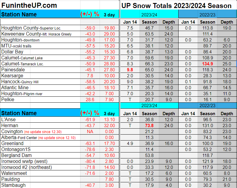
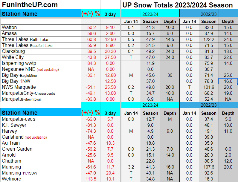
UP Snow Totals for Jan 14th below.
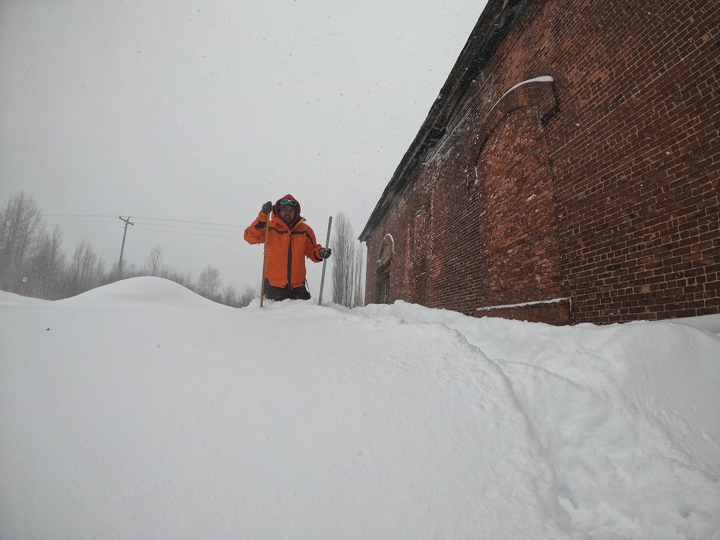
Above: standing in snowdrift about 3ft deep 1.14.24
You can see the season total +/- is growing closer to last year, but still a long way off last years season totals at this time.
I have again put a 3 day snow total column for the stations, but most of the stations really fell off now with snow today, but the Keweenaw still getting the snowstorm is why I provided it. I will do a 4 day tomorrow also, and probably a 5 day total. After Weds I think the snow should taper off.
T = trace, NR = No report, NA = Not Applicable
If daily slot is 0" the station hasn't updated or recorded no snowfall.
Sometimes a station won't update that day and does the next day or even days later.
Tahquamenon Falls State Park only updates at the end of each month.
Keweenaw county only updates during the weekdays.
Sanderson Field Airport (Soo) updates next day.
Most Snowfall Jan 15th: Painesdale with 9.8 inches
Most Snowfall, season to date: Herman with 73.8 inches
Biggest 24hr snowfall this season: Clarksburg with 26 inches (1.12.24)


