Today actually felt like winter again. Even though snow totals weren’t much today it was nice to see the trees branches and evergreens with snow clinging to them and the ground white again, after all it is supposed to be winter. After measuring my 6 snowfall stations today a friend and I went out to explore mine ruins, sledding, and check out ice build up on a waterfall to enjoy some of the white gold that has returned to the area.
Above: mine ruins in the Keweenaw - 1.6.24 - see these ruins on one of my Keweenaw tours
We are so far behind our normal season totals and far behind last years numbers at this point and most likely will end 40-50% less snowfall compared to last year by the time the snow stops falling in late April or May.
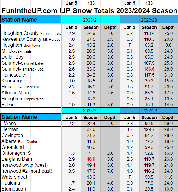
Across the UP snow totals were pretty consistent from 1-3 inches overnight. Bergland has taken back the number 1 spot but barely, we shall see what happens with the next 2 weeks if there’s much of a shakeup or new stations to the Top 10 or if any stations drop out. If you don’t watch the TOP 10 Snowiest Places in the UP Report Live on Facebook every Monday at 5pm, you should, just make sure you follow the FunintheUP page.
Above: frozen waterfall in the Keweenaw - 1.6.24 - see this one on one of my Keweenaw tours
Back at the end of Dec I was telling eveyone there would be some big snowfalls coming and it looks like the storms will be arriving. The first one may just slide south of the UP around the 9th/10th, the models slightly adjusted a little the last couple days, it held for over a week on projected path into the UP. Don’t worry though, this week and into the weekend it appears we will see plenty of lake effect snow and could see 10+ inches after the weekend is over. Then towards the middle of the month when the colder temps really set in a nice system the 3rd storm in line of hitting the Great Lake Region may just dump some more white gold.
Stay tuned for updates the next couple days with some snow totals for this week into the weekend. You might start seeing some crazy numbers from some stations and facebook pages so take them with a grain of salt, most of those places have no idea about lake effect impacts on snow for the UP which plays a huge role in our snow totals, which makes it even more challenging than the already challenging winter forecasting.
Well I have to off load some more video and images from sd cards from today before I get some shut eye and more adventures tomorrow, along with my daily measuring of 6 snowfall stations.
Paying subscribers make it possible for me to do these snow reports, videos, and live drives. Please consider becoming a paid subscriber so I can drive more often away from the Keweenaw and do more snow reports. Thanks so much for your support.
Also if you aren’t already I would ask you please subscribe to the FunintheUP Youtube channel
UP Snow Totals Below for Jan 5th
Guided UP Adventure Tours away from the crowds, waterfalls, overlooks, hidden gems, mine sites, Yooper rock picking, copper and greenstones picking
UpperPeninsulaTours.com with Yooper Steve
T = trace, NR = No report, NA = Not Applicable
If daily slot is 0" the station hasn't updated or recorded no snowfall.
Sometimes a station won't update that day and does the next day or even days later.
Tahquamenon Falls State Park only updates at the end of each month.
Keweenaw county only updates during the weekdays.
Sanderson Field Airport (Soo) updates next day.
Most Snowfall Jan 5th: Ironwood #2 with 3.5 inches
Most Snowfall, season to date: Bergland with 40.9 inches
Biggest 24hr snowfall this season: Bergland with 12.3 inches (10.29.23)


We finally got snow here in the lower peninsula yesterday. I was doing the 'Happy Dance'. Nice pictures of the old mine site and frozen waterfall. Looking forward to seeing more snow in the U.P. Thanks.