UP Snow Totals Jan 7/8/9
Big storm arriving, blizzard possible and sub zero temps.
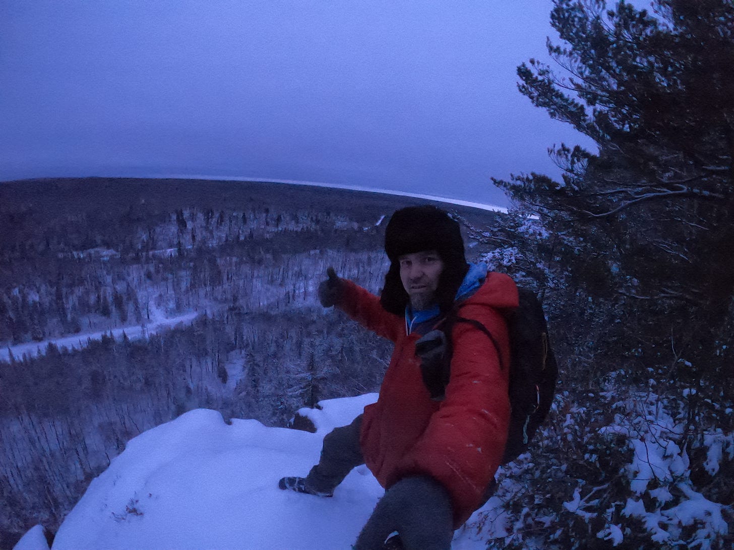
Above: hanging out at Albion overlook in the Keweenaw 1.8.24
Well winter has seemed to return, no big storms, and frankly I wouldn’t even say we had a storm yet. Still waiting for that good storm this year, looking into this weekend it looks like it just might happen. I posted awhile back about watching for a decent storm around the 15th, it appears to maybe be coming a little earlier, but we should still see snow through the week as well.
UpperPeninsulaTours.com - Adventures away from the crowds to hidden gems
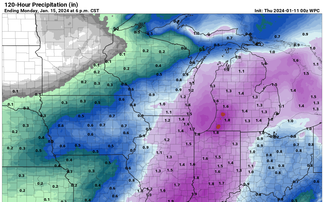
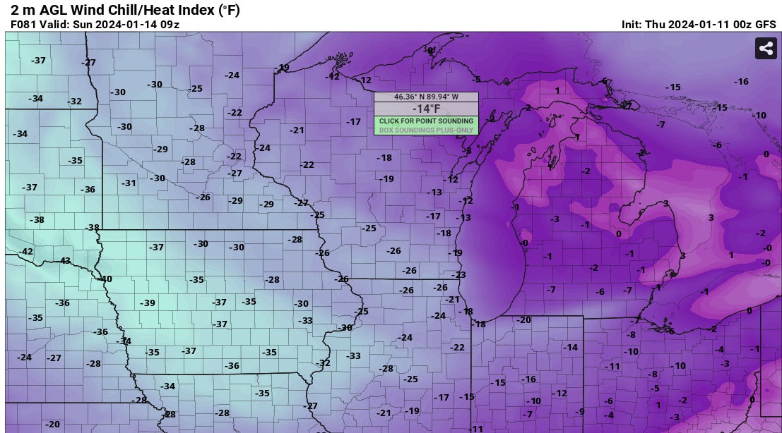
Looking at potential precip through Monday we could be seeing 6-12 inches of snow across the UP, light purple areas where greater snow amounts may occur. This system looks to be hanging out a little bit through the weekend into Monday. The Polar Vortex is appearing to start breaking up a bit bringing some colder air into the Great Lakes region, mid single digits with below zero wind chills this weekend, dress warm.
Now let’s look into the snowfall, temps, winds, coming this week. More forecast data and snowfall outlook in the paid members section.
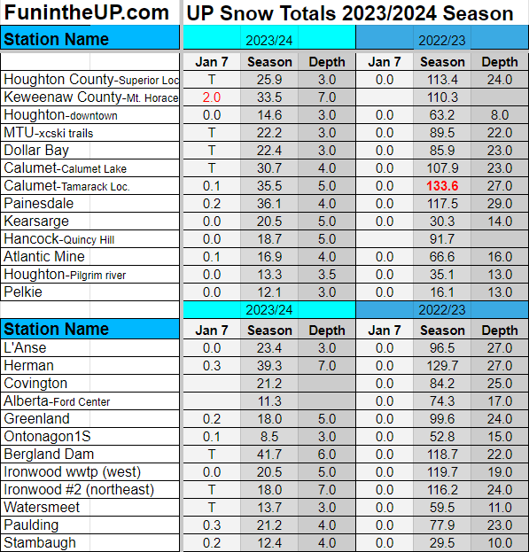
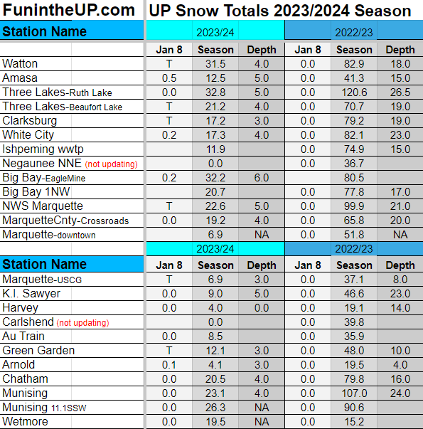
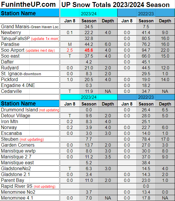
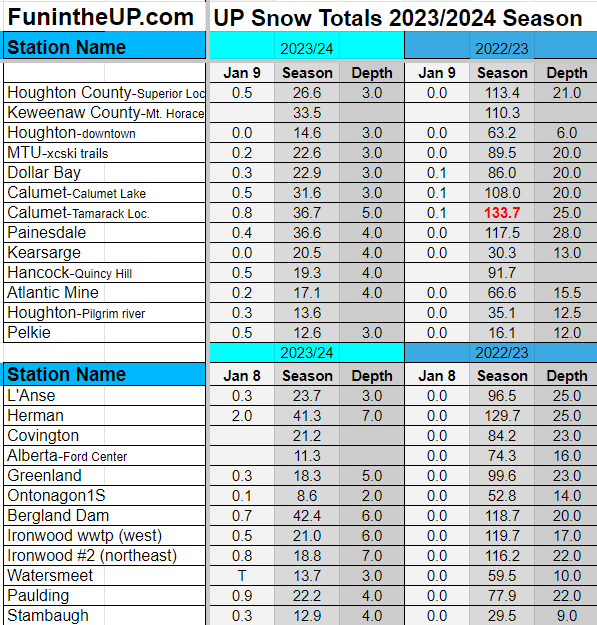
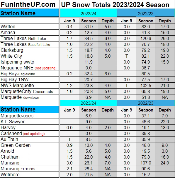
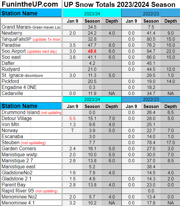
UP Snow Totals below for snow on Jan 7/8/9th
Paying subscribers make it possible for me to do these snow reports, videos, and live drives. Please consider becoming a paid subscriber so I can drive more often away from the Keweenaw and do more snow reports. Thanks so much for your support.
Also if you aren’t already I would ask you please subscribe to the FunintheUP Youtube channel
So we have the warmest Lake Superior waters since 1995, with the lake being wide open and this cold Artic air arriving with high winds we are expecting, this could be a big storm, perhaps blizzard conditions as well. I wouldn’t be surprised if the NWS comes out with blizzard warnings, wind chill warnings, and winter storm advisories by Friday morning for this weekend.
Thursday there may be some light snow, but nothing to extensive, just a little moisture hanging out, a few traces of snow, 1 inch at the most in areas.
Friday things start to get more interesting. Moisture moves in from the south, winds pick up, warm waters of Lake Superior adding to the mix may just start laying down the snow by mid morning on Friday latest early afternoon. Most of the UP should start to get blanketed by snow, the western UP might be a bit slower and not kick in until mid to late afternoon before it starts piling up. Friday snow totals should range from 2-6 inches across the UP.
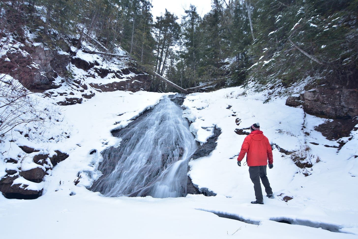
Above: Jacobs falls, Keweenaw 1.9.24
Eastern UP and those NE snow zones will see the heavier snow earlier on Friday and by Saturday winds look to shift from the NE to the N and some areas of NW and even W winds. We may see some gale force winds and even storm winds with this system through Saturday. Sunday looks to continue being windy with gale force winds and lake effect continuing through much of the day. Saturday and Sunday snow totals area really up in the air, I am expecting at minimum 5-8 inches between Saturday and Sunday into early Monday morning.
Temps will really start dropping about mid day Saturday with some low single digits and possibly even some sub zero temps in the Western and southern central UP.
Looking out past this weekend we should see snow almost everyday into next weekend as the cold air looks to be sticking around and with any winds over Lake Superior with the warm waters, it’s called extended lake effect snow.
I still don’t see any station in the UP reaching 95-100 inches by Jan 31st, really that’s pretty pathetic for a UP winter in my mind. Maybe I’ll be wrong, we shall see, one thing I know is there will be plenty of snow by the end of January to enjoy winter activities.
T = trace, NR = No report, NA = Not Applicable
If daily slot is 0" the station hasn't updated or recorded no snowfall.
Sometimes a station won't update that day and does the next day or even days later.
Tahquamenon Falls State Park only updates at the end of each month.
Keweenaw county only updates during the weekdays.
Sanderson Field Airport (Soo) updates next day.
Most Snowfall Jan 7th: Keweenaw county with 2 inches
Most Snowfall Jan 8th: Soo Airport with 2.5 inches
Most Snowfall Jan 9th: Detour Village with 5.5 inches
Most Snowfall, season to date: Soo airport with 48.6 inches
Biggest 24hr snowfall this season: Bergland with 12.3 inches (10.29.23)




Thank you for sharing